
What are the approaches, challenges, and successes to using UAVs in classes and for geospatial research?
Unoccupied aerial vehicles (UAVs), a.k.a. drones, are emerging technologies that are transforming numerous industries. In the environmental field, UAVs are changing the ways we monitor and collect data on land and over water, revolutionizing the quality and frequency of remote data collection that has previously been conducted via planes or satellites.
In this Research and Technology Forum, we heard from two Syracuse University faculty members who are applying UAVs in their own research, and developing educational programs to share this new technology with undergraduate and graduate students. First, presenters introduced us to different types of UAV technologies, how these technologies are being used by earth and environmental scientists, and provided several local examples from thermal and multispectral monitoring around Syracuse that show how UAV data is improving our understanding at the intersection of hydrology and water quality.
To round out the forum, we also discussed a new course, developed by Drs. Christa Kelleher and Jane Read, aimed at educating the next generation of environmental and earth scientists capable of using these tools when they leave Syracuse.
Presenters:
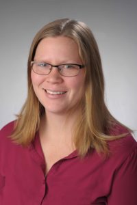
 Professor Christa Kelleher

Assistant Professor, Earth Sciences and Civil Engineering, Syracuse University
Dr. Kelleher’s research interests are at the interfaces between climate, hydrology, humans, and ecology, particularly using observations and mathematical models to investigate the organization of hydrology and water quality across spatio-temporal scales. Currently, she’s pursuing projects to examine the hydrologic role of vacant lots in urban areas, exploring the hydrologic controls on contaminants of emerging concern across Central New York, and the use of unmanned aerial vehicles to understand patterns of hydrology and water quality in Syracuse and beyond. Christa teaches courses in water science, hydrology, earth systems modeling, and applications of UAVs to environmental and earth sciences.
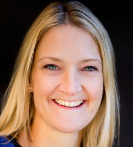
Professor Jane Read
Associate Professor, Geography, Syracuse University
Dr. Read specializes in geographic information systems, remote sensing, land use and land cover, and human-environment interactions. Much of her research has focused in the neotropics, including Costa Rica, Brazil, and Guyana, although she has also studied historical land changes in the Adirondacks of New York State, USA and more recently working with colleagues on a digital atlas project – Onondaga Lake: Finding a Restorative Center in Digital Space. She was the Director of Undergraduate Studies for Geography from 2014-2018 and is interested in ways to incorporate active learning into the classroom. She teaches courses in global environmental change, tropical environments, spatial thinking and geospatial technologies (GIS, remote sensing, UAVs), and spatial storytelling.
[vc_row][vc_column][vc_video link=”https://youtu.be/HxP7T6xFpLQ” el_width=”60″ align=”center”][/vc_column][/vc_row]
Research & Technology Forum Series
SyracuseCoE offers regularly scheduled forums and networking showcasing innovative research, technologies and other opportunities of interest to stakeholders and community members. Past topics have included groundbreaking industry projects to modernize the HVAC systems at the Sistine Chapel, workshops to help state agencies develop funding priorities, and research on the impact of “green” buildings on cognitive function. To receive notice of these events, sign up for email updates at the “Join our mailing list” tab at the bottom right corner of the website. Visit the Research & Technology Forum page to see the archive.